4 min read
NASA Atmospheric Wave-Studying Mission Releases Data from First 3,000 Orbits
Following the 3,000th orbit of NASA’s AWE (Atmospheric Waves Experiment) aboard the International Space Station, researchers publicly released the mission’s first trove of scientific data, crucial to investigate how and why subtle changes in Earth’s atmosphere cause disturbances, as well as how these atmospheric disturbances impact technological systems on the ground and in space.
“We’ve released the first 3,000 orbits of data collected by the AWE instrument in space and transmitted back to Earth,” said Ludger Scherliess, principal investigator for the mission and physics professor at Utah State University. “This is a view of atmospheric gravity waves never captured before.”
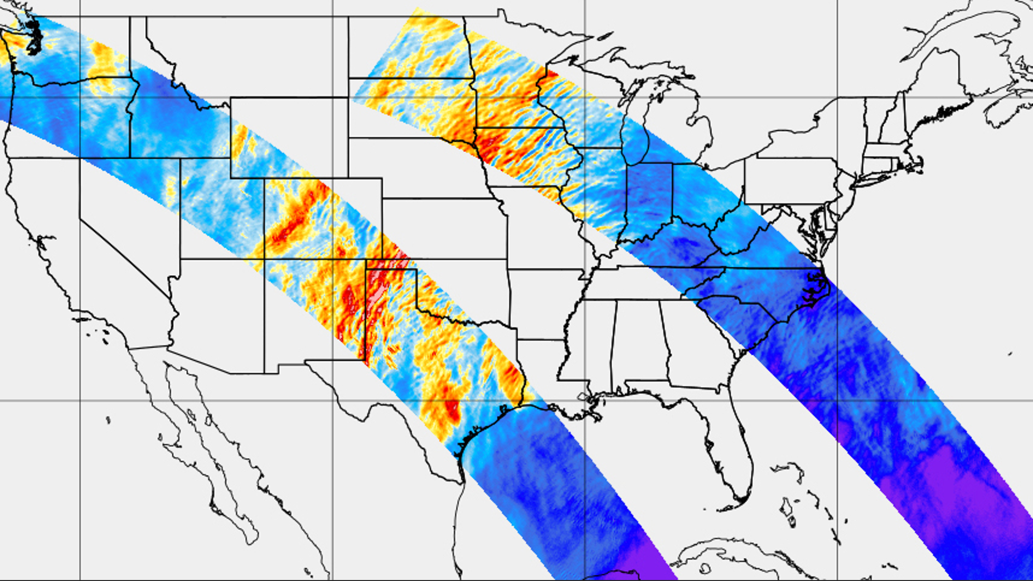
Available online, the data release contains more than five million individual images of nighttime airglow and atmospheric gravity wave observations collected by the instrument’s four cameras, as well as derived temperature and airglow intensity swaths of the ambient air and the waves.
“AWE is providing incredible images and data to further understand what we only first observed less than a decade ago,” said Esayas Shume, AWE program scientist at NASA Headquarters in Washington. “We are thrilled to share this influential data set with the larger scientific community and look forward to what will be discovered.”

Atmospheric gravity waves occur naturally in Earth’s atmosphere and are formed by Earth’s weather and topography. Scientists have studied the enigmatic phenomena for years, but mainly from a few select sites on Earth’s surface.
“With data from AWE, we can now begin near-global measurements and studies of the waves and their energy and momentum on scales from tens to hundreds and even thousands of kilometers,” Scherliess said. “This opens a whole new chapter in this field of research.”
Data from AWE will also provide insight into how terrestrial and space weather interactions affect satellite communications, and navigation, and tracking.
“We’ve become very dependent on satellites for applications we use every day, including GPS navigation,” Scherliess said. “AWE is an attempt to bring science about atmospheric gravity waves into focus, and to use that information to better predict space weather that can disrupt satellite communications. We will work closely with our collaborators to better understand how these observed gravity waves impact space weather.”

The tuba-shaped AWE instrument, known as the Advanced Mesospheric Temperature Mapper or AMTM, consists of four identical telescopes. It is mounted to the exterior of the International Space Station, where it has a view of Earth.
As the space station orbits Earth, the AMTM’s telescopes capture 7,000-mile-long swaths of the planet’s surface, recording images of atmospheric gravity waves as they move from the lower atmosphere into space. The AMTM measures and records the brightness of light at specific wavelengths, which can be used to create air and wave temperature maps. These maps can reveal the energy of these waves and how they are moving through the atmosphere.
To analyze the data and make it publicly available, AWE researchers and students at USU developed new software to tackle challenges that had never been encountered before.
“Reflections from clouds and the ground can obscure some of the images, and we want to make sure the data provide clear, precise images of the power transported by the waves,” Scherliess said. “We also need to make sure the images coming from the four separate AWE telescopes on the mapper are aligned correctly. Further, we need to ensure stray light reflections coming off the solar panels of the space station, along with moonlight and city lights, are not masking the observations.”
As the scientists move forward with the mission, they’ll investigate how gravity wave activity changes with seasons around the globe. Scherliess looks forward to seeing how the global science community will use the AWE observations.
“Data collected through this mission provides unprecedented insight into the role of weather on the ground on space weather,” he said.
AWE is led by Utah State University in Logan, Utah, and it is managed by the Explorers Program Office at NASA’s Goddard Space Flight Center in Greenbelt, Maryland. Utah State University’s Space Dynamics Laboratory built the AWE instrument and provides the mission operations center.
By Mary-Ann Muffoletto
Utah State University, Logan, UT
NASA Media Contact: Sarah Frazier