NASA Data Supports Everglades Restoration
This story is the second installment of a series on NASA’s mission to measure greenhouse gases in Florida’s mangrove ecosystem. Read the first part here.
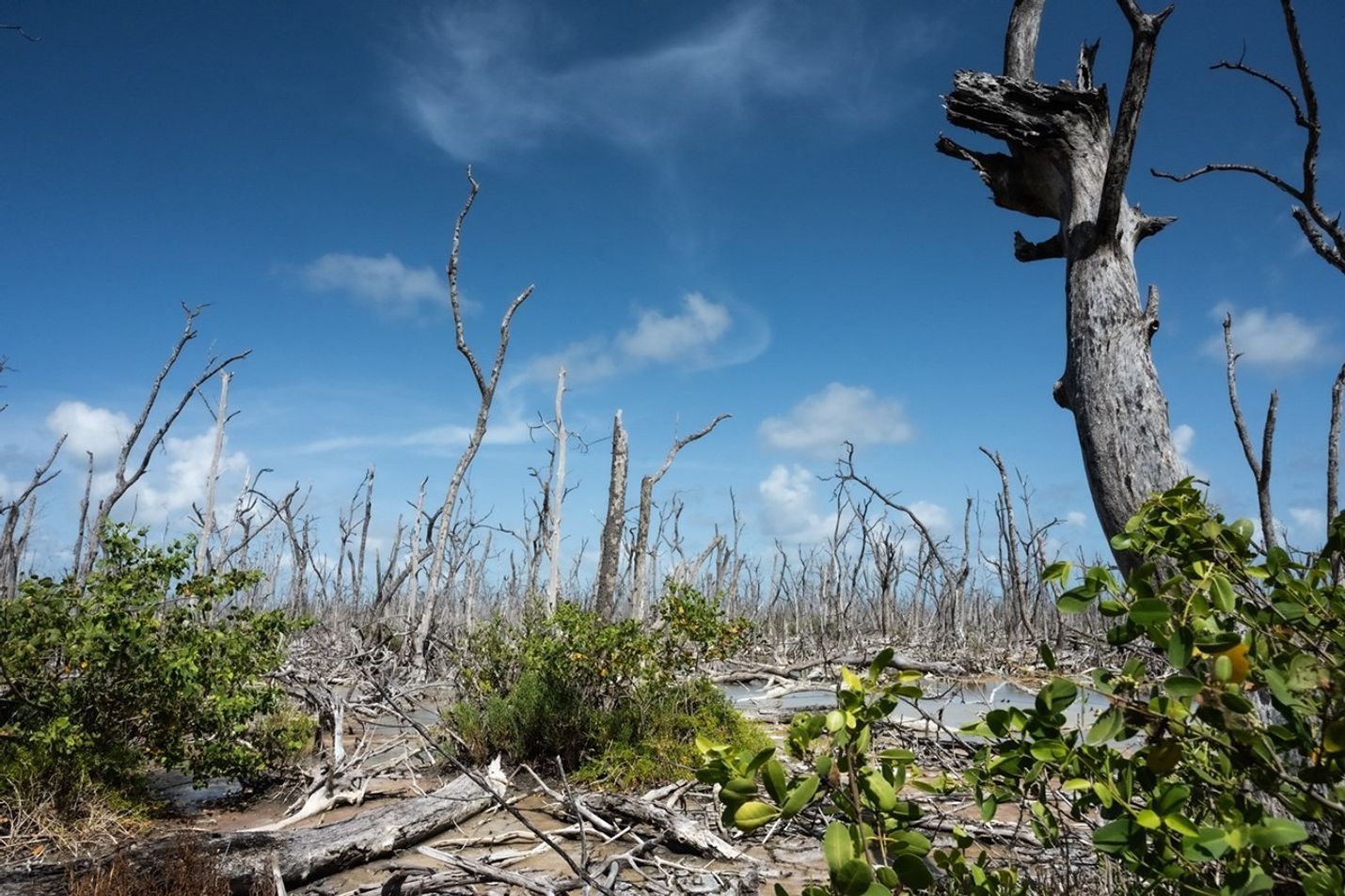
Along the southernmost rim of the Florida Peninsula, the arching prop roots of red mangroves line the coast. Where they dip below the water’s surface, fish lay their eggs, using the protection from predators that the trees provide. Among their branches, wading birds like the great blue heron and the roseate spoonbill find rookeries to rear their young. The tangled matrix of roots collects organic matter and ocean-bound sediments, adding little by little to the coastline and shielding inland biology from the erosive force of the sea.
In these ways, mangroves are equal parts products and engineers of their environment. But their ecological value extends far beyond the coastline.
Tropical wetlands absorb carbon dioxide (CO2) from the atmosphere with impressive efficiency. Current estimates suggest they sequester carbon dioxide 10 times faster and store up to five times more carbon than old-growth forests. But as part of the ever-changing line between land and sea, coastal wetlands are vulnerable to disturbances like sea level rise, hurricanes, and changes in ocean salinity. As these threats intensify, Florida’s wetlands — and their role as a critical sink for carbon dioxide — face an uncertain future.
A new data product developed by NASA-funded researchers will help monitor from space the changing relationship between coastal wetlands and atmospheric carbon. It will deliver daily measurements of gaseous flux — the rate at which gas is exchanged between the planet’s surface and atmosphere. The goal is to improve local and global estimates of carbon dioxide levels and help stakeholders evaluate wetland restoration efforts.
NASA measures carbon dioxide from ground, air and space

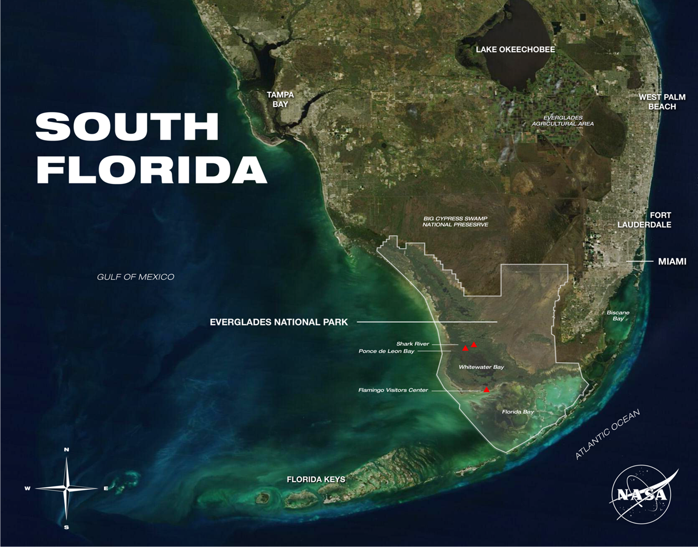
In the Everglades, flux measurements have historically relied on data from a handful of “flux towers.” The first of these towers was erected in June 2003, not far from the edge of Shark River at a research site known as SRS-6. A short walk from the riverbank, across a snaking path of rain-weathered, wooden planks, sits a small platform where the tower is anchored to the forest floor. Nearly 65 feet above the platform, a suite of instruments continuously measures wind velocity, temperature, humidity, and concentrations of atmospheric gases. These measurements are used to quantify the amount of carbon dioxide that wetland vegetation removes from the atmosphere — and the amount of methane released.
“Hundreds of research papers have come from this site,” said David Lagomasino, a professor of coastal ecology at East Carolina University. The abundance of research born from SRS-6 underscores its scientific value. But the BlueFlux campaign is committed to detailing flux across a much larger area — to fill in the gaps between the towers.
Part of NASA’s new greenhouse-gas product is a machine-learning model that estimates gaseous flux using observations made by the Moderate Resolution Imaging Spectroradiometer (MODIS) instruments on NASA’s Aqua and Terra satellites. The MODIS instruments capture images and data of South Florida every one to two days, measuring the wavelength of sunlight reflected by the planet’s surface to produce a dataset called surface spectral reflectance.
Different surfaces — like water, vegetation, sand, or decaying organic matter — reflect different wavelengths of light. With the help of some advanced statistical algorithms, modelers can use these measurements to generate a grid of real-time flux data.
To help ensure the satellite-based model is making accurate predictions, researchers compare its outputs to measurements made on the ground. But with only a handful of flux towers in the region, ground-based flux data can be hard to come by.
To augment existing datasets, NASA researchers use a relatively new airborne technique for measuring flux. Since April 2022, NASA’s airborne science team has conducted 34 flights equipped with a payload known colloquially as “CARAFE,” short for the CARbon Airborne Flux Experiment. The CARAFE instrument measures concentrations of methane, carbon dioxide, and water vapor, generating readings that researchers combine with information about the plane’s speed and orientation to estimate rates of gaseous flux at fixed points along each flight’s path.
“This is one of the first times an instrument like this has flown over a mangrove forest anywhere in the world,” said Lola Fatoyinbo, a forest ecologist at NASA’s Goddard Space Flight Center in Greenbelt, Maryland.

Early findings from space-based flux data confirm that, in addition to acting as a sink of carbon dioxide, tropical wetlands are a significant source of methane — a greenhouse gas that traps heat roughly 80 times more efficiently than carbon dioxide. In fact, researchers estimate that Florida’s entire wetland expanse produces enough methane to offset the benefits of wetland carbon removal by about 5%.
“There are also significant differences in fluxes between healthy mangroves and degraded ones,” Fatoyinbo said. In areas where mangrove forests are suffering, say after a major hurricane, “you end up with more greenhouse gases in the atmosphere.” As wetland ecology responds to intensifying natural and human pressures, the data product will help researchers precisely monitor the impact of ecological changes on global carbon dioxide and methane levels.
‘We need this reliable science’
The Everglades today are roughly half their original size — primarily the result of a century’s worth of uninterrupted land development and wetland drainage projects. It’s difficult to quantify the impact of wetland losses at this scale. Florida’s tropical wetlands aren’t just an important reminder of the beauty and richness of the state’s natural history. They’re also a critical reservoir of atmospheric carbon and a source of drinking water for millions of South Florida residents.
“We know how valuable the wetlands are, but we need this reliable science to help translate their benefits into something that can reach people and policymakers,” said Steve Davis, chief science officer for the Everglades Foundation, a non-profit organization in Miami-Dade County that provides scientific research and advocacy in an effort to protect and restore the Everglades.
As new policies and infrastructure are designed to support Everglades restoration, researchers hope NASA’s daily flux product will help local officials evaluate their restoration efforts in real time — and adjust the course as needed.
The prototype of the product, called Daily Flux Predictions for South Florida, is slated for release this year and will be available through NASA’s Oak Ridge National Laboratory (ORNL) Distributed Active Archive Center (DAAC).
NASA’s Goddard Space Flight Center, Greenbelt, Maryland