In some ways, Benin City is like dozens of other fast-growing cities in Nigeria. Buoyed by burgeoning industrial and agricultural sectors, the city’s population rose by 1.7 million people over the past four decades as its footprint on the West African landscape expanded several times over.
Amid bustling new networks of roads, residential neighborhoods, markets, and workshops, lie signs of a much earlier era, when the city was the seat of a powerful pre-colonial kingdom. Remnants of ancient earthworks, thought to be among the longest in the world, can even be seen in images of the city captured from space.
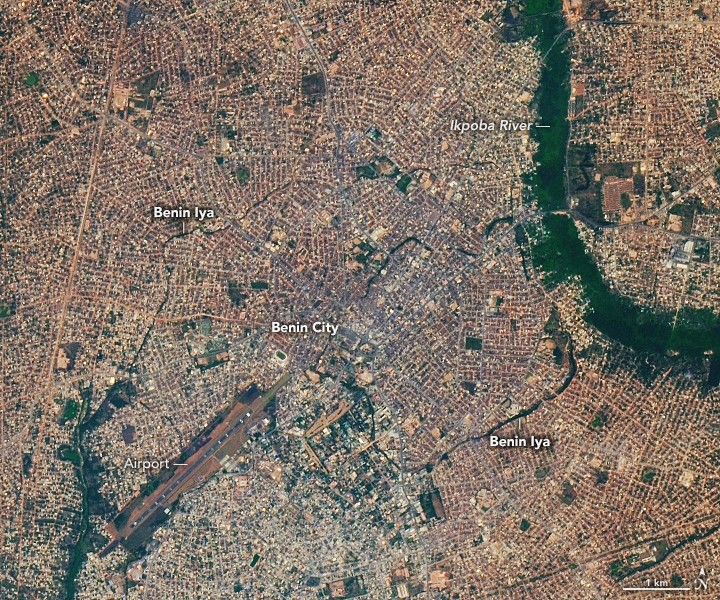
Benin Iya (sometimes called the Benin Earthworks, the Walls of Benin, and the Benin Moat) is a vast, cellular network of interlocking earthen walls, ramparts, and ditches that radiate outward from a central moat at the heart of the city. Built in sections over hundreds of years between the 7th and 14th centuries, the system was key to marking defensive, political, and economic boundaries and played an important role in maintaining order and stability in the Kingdom of Benin.
The OLI-2 (Operational Land Imager-2) on Landsat 9 captured this image of the remains of earthworks on January 11, 2025. The features appear as dark green lines that trace arcing patterns in a densely settled area near the airport on the west bank of the Ikpoba River. Trees and vegetation growing in the moats give the features a dark green color.
Most of the earthworks consisted of relatively narrow and shallow linear ramparts and ditches that spread widely across the landscape. Many sections have been destroyed or are too small or too obscured by modern development to be easily detected by satellites or astronauts in orbit. However, some inner sections that run through the modern Oredo, Egor, and Ikpoba-Okha areas of the city had true walls and moats and are among the most visible in Landsat imagery.
Archaeological research indicates that the earthworks spanned more than 16,000 kilometers (10,000 miles) and enclosed roughly 6,500 square kilometers (2,500 square miles)—an area as large as the U.S. state of Delaware. Such length means the features hold the Guinness World Record for being the “longest earthworks of the pre-mechanical era.” By some measures, the features were together significantly longer than the Great Wall of China.
NASA Earth Observatory image by Lauren Dauphin, using Landsat data from the U.S. Geological Survey. Story by Adam Voiland.
References & Resources
- Guinness World Records Longest earthworks of the pre-mechanical era. Accessed November 25, 2025.
- The Met (2025, May 31) Benin City Earthworks and Urban Planning, Nigeria. Accessed November 25, 2025.
- MOWAA The Benin Iya Survey. Accessed November 25, 2025.
- MOWAA Benin City’s Moat (Iya) System. Accessed November 25, 2025.
- Onwuanyi, N. et al. (2021) The Benin City Moat System: Functional Space or Urban Void? African Journal of Environmental Research, 3(1), 21-39.
- Schepers, C. et al. (2025) Current Condition of the Iya in Benin City, the Gates and Future Preservation Strategies. African Archaeological Review, 42, 519-537.
- UNESCO (1995) Benin Iya / Sungbo’s Eredo. Accessed November 25, 2025.
- World Monuments Fund (2025) Benin City Earthworks. Accessed November 25, 2025.

You may also be interested in:
Stay up-to-date with the latest content from NASA as we explore the universe and discover more about our home planet.

Researchers are using satellites to study development patterns in this fast-growing city in Ethiopia.

The Santarem plateau in the northern Brazilian state displays a patchwork of cleared and uncleared land bordering a densely forested…

New York City’s Manhattan Island was the site of the nation’s first Labor Day parade on September 5, 1882.


